Originally published in Lake of the Woods Area News, Volume 55, Number 4, Fall 2025
In late July, four friends and I set out on an adventure to a part of the lake that we seldom visit—that strip of islands bordering the northern expanse of the Little Traverse. A couple of our group had been there within the last few years, for one it had been over 40 years and for another, it was a completely new experience. For many years, that trip had been an annual event for our family, as we participated in the Oak Island to Warroad sailing race each July, but it had been 21 years since I had last boated to that area.
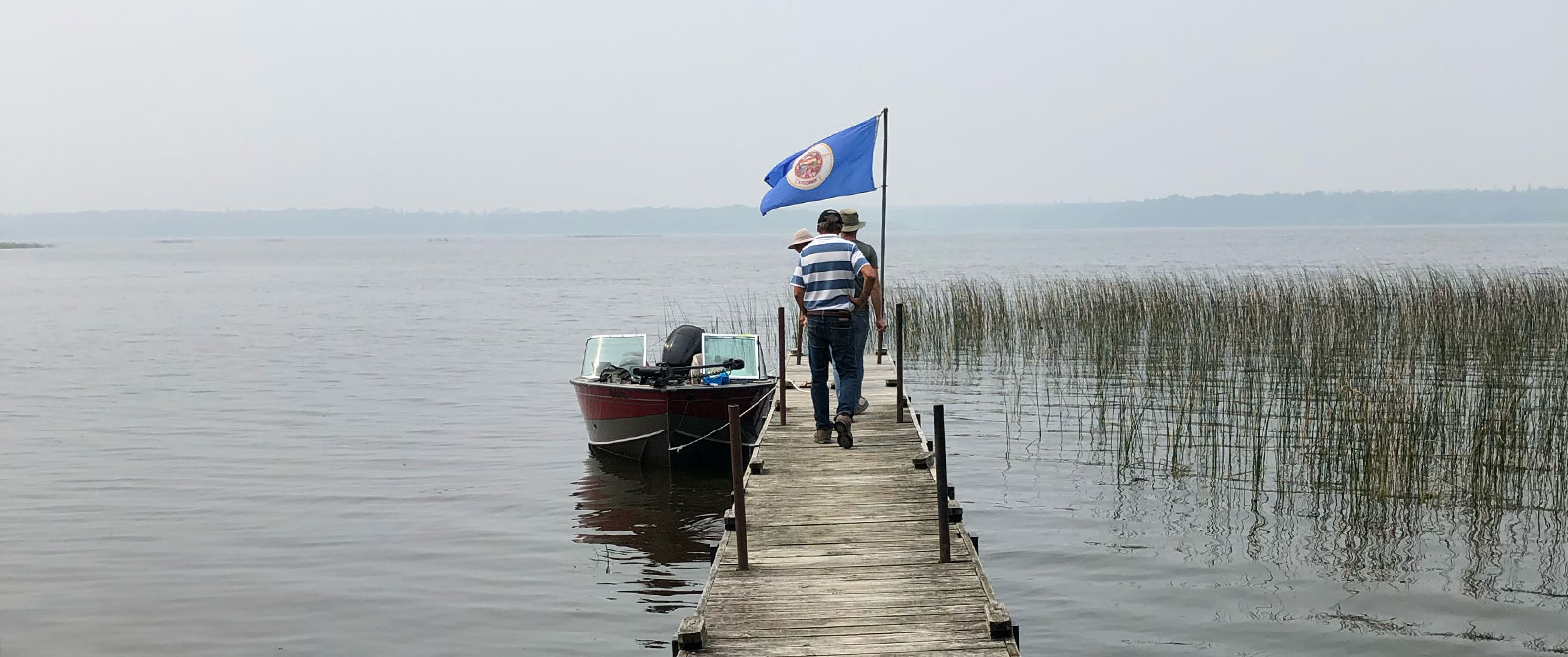
As we set off from our captain’s home in Storm Bay at around 9:30 a.m., it was with a sense of excitement and anticipation. On our itinerary, among other things, were two historically significant locations—Massacre Island and Fort St. Charles.
If you want to follow with a chart, our route took us through The Hades, down through The Elbow, west to Crescent Island, then south to French Portage Narrows. We chugged through the Tug Channel and emerged north of Gardner Island and tracked southwest to what is known on charts as Massacre Island.
I phrase it that way because there is some question as to whether this is actually the island where, in 1736, the bodies of Jean Baptiste La Verendrye, Father Aulneau and 19 voyageurs were found, beheaded and slain by the Sioux. In 1890, Jesuits from St. Boniface College organized an expedition to Lake of the Woods with the hope of finding the location of the tragedy. With the help of locals who, through tradition, knew of its location, they erected a cross on the highest hill of this island. On Canadian lake charts after 1905, the island (originally known as Manitou) was renamed Massacre.
The island is relatively large—roughly 3/4 of a mile long and 1/4 mile wide, encompassing about 100 acres of land. As we circumnavigated it, looking for the cross (which we did not find), we noted the unique cobblestone shoreline and what seemed like dense growth up the rise to the high point of the island. A couple of our travelers are canoeists and they speculated about where a logical landing point would have been for the voyageurs. It was hard to determine one. We noted though, at that time, the water would have been about three feet lower (before the dam at the north end of the lake was built). We discussed the possibility of another island being the site. It is smaller and on the American side of the border and was once known on lake charts as Ile du Massacre.
A researcher I know has been trying to determine the real site for the last 6+ years. In my last communication with him, he noted that his research continues and has extended beyond the geographical location of the event to the broader context of what he has now reinterpreted as a battle rather than a massacre. I’m looking forward to hearing more about his work.
As we pulled away from the island to the north to take a long view, we happened upon a beautiful lunch spot on Willow Island. We beached the boat on a sandbar that connects the island to a smaller, treed rocky outcropping, disembarked, explored a bit and then settled in for some lunch. Notable on this island were the large stands of oak trees which some suggest are an indication of early habitation since the oak is not natural to the area.
Our afternoon tour took us past the south side of Oak Island and up towards Flag Island. Along this stretch we were reminded of the incredible difference of the northern and southern halves of the lake. When we looked to the south, all we saw was wide open water. There was not an island in sight and we talked of times we crossed that larger body of water with only a compass for navigation.
Since our next stop was Fort St. Charles on Magnussons Island, which is in the United States, we checked in with American Customs at Young’s Bay Resort at the Northwest Angle. The check-in is a fairly straightforward process involving a small, enclosed kiosk with an iPad in which we entered our boat information and the passport information of each traveler.
“Whitewater” and “bluewater” were terms that we heard spoken by our captain and navigator as they back-and-forthed about our route. The reference was to water depths as indicated on the charts—whitewater being over nine feet, bluewater being less. There was a fair bit of bluewater as we approached Magnussons Island from the northeast. It’s marshy and weedy, but there is a clearing into the landing at Fort St. Charles, although as we docked at the very end of the pier, our stop was facilitated by a slide into mud.
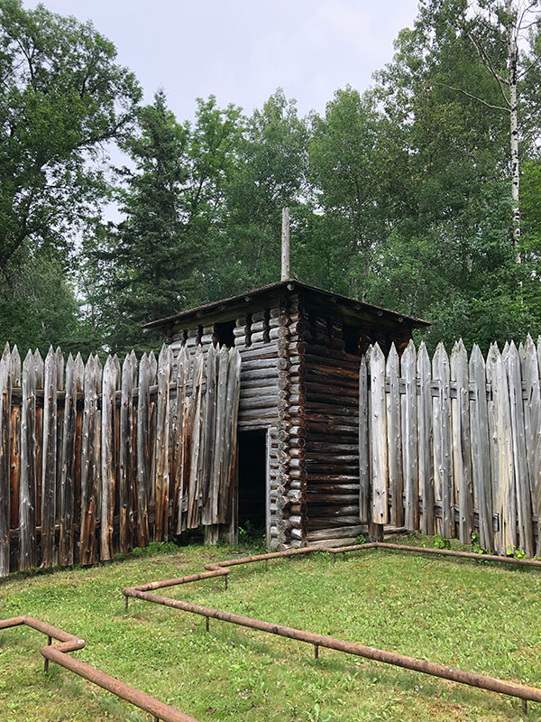
The grounds at the site are well-kept. Trees have been cleared, grass cut and there are a couple of interpretive panels to provide context.
Fort St. Charles was established by Pierre de La Verendrye, explorer and fur trader, in 1732 and was in use until 1749. It served as a base for his explorations west in search of the Western Sea and for his fur trading operations. The fort was abandoned in the 1750s as the war between France and England abruptly shut down the French fur trade in North America. Its fate was left to the ravaging elements of the northern climate, and it was largely consumed by the encroaching forest.
It wasn’t until 1908 that Fort St. Charles was rediscovered by an expedition of members of St. Boniface College. From information provided by Chief Powassin of the Northwest Angle, they found a cove similar to the one he described. Systematically they beat through the bush, finding flat chimney stones, fireplaces, and the decaying stumps of the old blockade—the remains of La Verendrye’s fort.
Forty years later, the Fourth Degree Knights of Columbus of Minnesota became interested in permanently marking the site of the historic fort and, over the next ten years, work crews rebuilt the stockade and indicated the known buildings with foundation timbers (now replaced by steel piping). This was the reconstruction we visited.
The only building within the palisade walls is the chapel which was built in 1955. As noted, other buildings are indicated by steel pipes that mark the footprint of each. There are inscriptions on the piping that indicate a mess hall, quarters for the missionaries, bunkhouses for the voyageurs, etc. This is helpful in understanding the layout within the 100 by 60 foot enclosure but the full scale of the community is difficult to imagine without the actual buildings. We wondered how many men lived there. We discussed the location of the site and why it would have been chosen. We considered an area that might have been used for a garden. I was struck once again by the power of place—being where the story was set, where history happened, where lives were lived.
On the way to the next stop on our journey, one of the company spotted a bear on the shoreline of the island we were passing. We cruised in closer and observed him as he observed us. He appeared unperturbed by our presence. It was one of those wildlife sightings that will stay with us for a long time.
Our next stop was Monument Bay—a story for another time—then we wound our way through Bishop Bay and up beautiful Tranquil Channel. We popped through the Barrier Islands at Crow Rock and headed back to Kenora via Welcome Channel. Our check-in with Canada Customs was at Kenora’s Harbourfront.
Our company of adventurers arrived back at home base shortly before 6:00 p.m. During our trip, one of the adventurers had cited a Willa Cather quote as she took in the landscape and waterscape surrounding us:
…that is happiness; to be dissolved into something complete and great.”
That day, it felt like we had dissolved into the completeness and greatness of Lake of the Woods. It was pure happiness.