Originally published in Lake of the Woods Area News, Volume 55, Number 3, Summer 2025
At the end of May the level of Lake of the Woods was 322.89 m (1059.3 ft.), which was within the normal range for the lake level at that time of the year. This level was also consistent with the target set for end of May of 322.9 m (1059.4 ft.) in the March Control Board Regulation Strategy.
Spring conditions in the Winnipeg River Basin including Lake of the Woods had extreme weather fluctuations particularly during the month of May. At the end of April and the beginning of May there was above normal rainfall over much of the Lake of the Woods and the Rainy-Namakan basins with the highest amounts in the in the 50 to 75 mm (2 to 3 in) range. By comparison the average rainfall typically received in the last quarter of April is approximately 10 mm (0.4 in). These heavy rains resulted in high tributary flows and lake inflows with a related rise in lake and river levels. Beginning in the second week of May however the weather pattern changed and the Winnipeg River Basin experienced extremely hot and dry conditions.
Many communities in the region broke decades old heat records with temperatures exceeding 31°C. Along with the heat came a reduction in precipitation which resulted in tributary flows peaking and the slowing of the rise in lake and river levels.
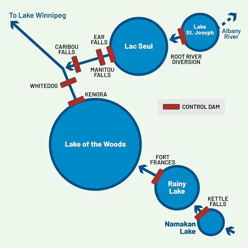
The hot and dry weather also resulted in extreme heat warnings and the beginning of an active forest fire season in the region. Wildfires resulted in the evacuation of the First Nation community of Wabaseemoong northwest of Kenora as well as staff of control dams including Whitedog on the Winnipeg River and Caribou Falls on the English River system which feeds into the Winnipeg River. These dams can be remotely managed in an emergency however Control Board staff temporarily paused outflow changes from the Lake of the Woods to the river and stabilized flow for several days while the facilities were without crews. During this time Control Board staff maintained close contact with dam operators for regular situation updates and assessments. The extreme heat in early May was followed by a dramatic change in weather as we approached the May long weekend when cold and wet weather replaced the hot and dry conditions. On the long weekend many communities such as Sioux Narrows had snow.
Snow is unusual for the time of year and the latest measurable snowfall in the Kenora area was recorded on May 24, 1963. Regardless of how the precipitation fell it was a welcome change to help reduce the fire risk. As we have learned our weather patterns are increasingly variable and a challenge to predict.
As summer approaches the Control Board and its Secretariat work closely with partners throughout the Winnipeg River Drainage Basin. Secretariat staff closely monitor the whole upstream watershed and operations at Fort Francis and Kettle Falls as well as downstream outflows from Lake of the Woods to the Winnipeg River to achieve system target levels for the summer. As of this writing we are well on track to meet the summer recommended target level for Lake of the Woods in the range of 322.78 to 323.09 m (1059 to 1060 ft.). This level compares with Ft 322.8 m (1059.0 ft.) on your nautical charts
Have a great summer at the lake. Please keep a close watch on local conditions and remember to consider the varying levels of the lake due to changing weather and wind tides. For up-to-date information on the work of the Control Board please visit the web site at lwcb.ca.